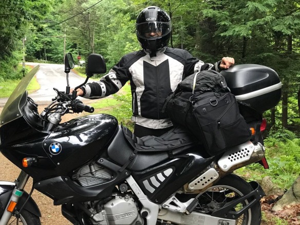
Leaving for a three-night camping expedition to the Delaware Water Gap National Park area in northern New Jersey. It’s sort of the flip side of the trip I took to Maine a while back. 180 degrees in the opposite direction, but about the same distance.
I’m wearing my three season Sedici jacket here and insulated underwear. With a cloudy, 60-degree ride down, the heat gradually drained out of me and around Brattleboro, VT I was needing a place to warm up. I got rained on three times. Coming back was hot and I wore the summer RevIt jacket which lets the air right through.
If I set the Google Map options to “Avoid Highways” I get the following route:
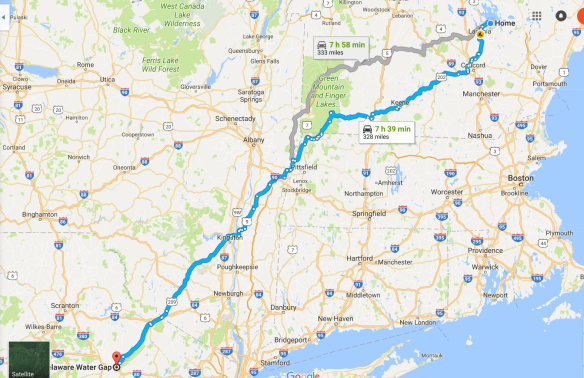
It’s a nice, direct scenic run out through the Green Mountains, loosely following the Appalachian Trail down to the park. The AT passed about 1/2 mile from our campsite, and we were able to hike a few miles on it. Perfect.
I had plugged a USB power outlet into the connector I normally use for the Battery Tender, straight connection to the battery. Bought a $10 phone mount and mounted the iPhone 7 on the handlebars with the charging cord coming out from under the seat. This worked great. I was able to navigate all the way and the phone stayed charged at 100%.
As you are passing through a complex intersection of roads, you can just glance at the screen and see your path through. You don’t have to read all the signs. I think it’s safer.
But there are some quirks to “No Highways”. It apparently computes the quickest route, which is good, but it will often avoid the center of towns. That can be good or bad. If you are sort of looking for gas or food, you might not go by any stations, stores, or restaurants. I wound up in the middle of the national park with very little gas and had to specifically go out and find some. I had started looking at 100 miles on the odometer and was approaching 150 when I finally filled up. Normally, I fill up around 125.
It does seem to like sending you by lakes and rivers, which is nice.
It seems overly averse to construction zones. Just leaving Laconia, it sent me on an unnecessary detour. On the way back from the DWG it dumped me into downtown Albany, NY, apparently looking for a non-highway, no construction way to get across the Hudson River. That’s not the way I went on the way down.
Also, using the navigate mode tends to leave you in the dark about where you are, exactly. You know how far it is to the next turn, how far it is to your destination, but you don’t have an overall sense of where you are and what is around you just beyond your vision.
Finally, it is too strict about “no highways”. On one occasion, I felt like I was riding through people’s back yards right next to the highway. Better to take the highway if all you are going to do is parallel it on much, much slower roads.
By the way, it was my wife and I making the trip, but she drove her Infiniti G37X, cruising in air-conditioned comfort while blasting Amos Lee on the Bose. We each got what we wanted.
